

Badgers Springs, Tiptop Ghost Town, Perkinsville Arizona
It's A Perfect Month To Explore This Trifecta
April 1, 2019

Perkinsville Rd: The view is just as beautiful on the way to Jerome. Several turns in the road let you see the peaks.
For April: A Hike, A Ride, and A Drive
April is a great month to explore the Arizona desert. It isn't too hot yet, not too cold, and there are still wildflowers and cactus blossoms to be found, not to mention the masses of yellow palo verde blossoms. To help you enjoy some of the prettiest places I know of in the desert, I've compiled three adventures for you: a walk, a ride, and a drive. No matter what your fitness level is, one of these will work for you this April.
A Hike: Badgers Springs
If you've driven on I-17 between Phoenix and Camp Verde, you've passed Badger Springs Road. However, you may not know that there is a great little hike near the end of the road. Just take Badger Springs Road east for just over three quarters of a mile and you'll find a restroom and parking. It's a dirt road, but passenger cars should do just fine.
The trail begins a little way past the restroom, and heads down into Badger Springs wash. When we were there, Badger Springs creek was running - not enough to hinder, just enough to be pretty. We were easily able to avoid walking in the water.
Petroglyphs
The wash itself is very pretty, with steep walls and lots of vegetation and shade. There is a spring in the wash, and there is almost always water around it, making a very picturesque little area. The wash goes down to the Agua Fria River in a very short time - it only takes about a 20 minute walk to get there. But before you hurry out of the wash to the river, take a little side trail to your left and you'll find a bunch of very nice petroglyphs.
Where the wash meets the river, there is a great little pool with sandy beaches and plenty of trees and shade. Both upstream and down the river flows over big rocks and boulders, making little waterfalls and pools. The trail officially ends at the river (it's only about a mile and half there and back), but you can explore upstream or downstream.
Downstream
Downstream is really beautiful, with some more good pools and plenty of places on the shore to have a picnic or just sit and watch the kids splash in the water. You can't really swim, but you can have a good time wading and playing.
A Ride: Tiptop Ghost Town
Tiptop was one of the first rides that John and I ever took when we first got our OHV. This was even pre-Mochi (our French Brittany), when we still had the two-seater Arctic Cat Wildcat Trail. Plan to spend most of the day, because the trip is out and back, about 25 miles total, plus there is lots of exploring to do when you get there. It's a fairly well-traveled road, but you do definitely need a 4WD vehicle to do this trip.
Deciphering The Route
This area is constantly going through changes, and in November of 2018, a gate was put in near the Tiptop Townsite. As far as I know, it hasn't been locked, but a lot of the websites for off-roading are not updated very often, and I can't find any information that is from 2019.
To get there, take Table Mesa Road (exit 236 off I-17) and head west. Follow Table Mesa Road for just under a mile. There are lots of places that you can stage, including one with a restroom. It's about three miles down the road.
I strongly suggest you download a route description online, as there are lots of turns and it isn't easy to find on your own. If you have an interactive My Topo app installed on your phone, that really helps - you can see where you are, and where you want to be, so you can decipher the route on the fly.
Old Native American Fort
One of the fun things you'll pass on the way to Tiptop is an old Native American fort on a little hilltop. It's less than half a mile detour, so be sure to check it out. You can hike up to the top (it's pretty short and easy), and there's a great view from up there.
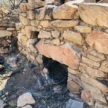
The road is rough and rocky, with many creek crossings - make sure your vehicle is in good condition and bring plenty of water and supplies. Most of the time you won't have cell service. Tiptop was a rough and tumble mining town, and at one time they even had a post office. Lots of silver and other ores came out of the mines, and there are a lot of old ruined buildings and foundations to see.
A Drive: Chino Valley To Perkinsville To Jerome
We took the Verde Canyon Railroad from Clarkdale to Perkinsville last fall, and the area around there is so beautiful that we decided we needed to find out if there was a way to drive in. Perkinsville at one time boasted ten to twelve families, but it is now a ghost town. You can't get to Perkinsville any more - a ranch has closed the gate, but that doesn't mean you shouldn't drive the Perkinsville Road.
Verde Canyon Railroad
If you take the Verde Canyon Railroad you can actually see what's left of Perkinsville, but you don't get off the train. It just stops there, then heads back the way it came. That train ride, by the way, is awesome and you should do it.
For the drive, start in Chino Valley and take the Perkinsville road northeast. The pavement ends not too long into the trip, but it's a very good road and you should have no trouble with it. There are lots of little side roads and we visited several pretty water holes.
Epic Scenery
The scenery is epic - views of red rock canyon walls with the San Francisco Peaks behind them were breathtaking – the peaks were covered with snow. You get to see that amazing view for quite a long time before you drop down too low to see the peaks, but they show up again after you head back down to Jerome.
At one point on the way in, there is an overlook with an information kiosk and a bench where you can enjoy that glorious view of the red rocks and the peaks. This is where we had lunch.
Jerome and Perkinsville

Perkinsville Rd: This is a photo of the route, taken from the DeLorme Atlas and Gazetteer of Arizona. This is a fabulous map book -- I highly recommend it. You can pick one up at Sportsmans Warehouse or Wide World of Maps.
About twenty miles in, you'll reach a T - Jerome is to the right, and Perkinsville is to the left. Go left at first and you'll cross a great one-line bridge over the Verde River. Just past the bridge, turn right and you'll find lots of room for parking and picnicking.
Several footpaths lead to the water's edge and the river is beautiful here. We explored and hiked around for quite a while. There were lots of birds, too.
To get to Jerome, head back over the bridge the way you came, and just follow the road past where you came in. There are incredible views from this part of the road as well. The road is a bit twisty in places, but not scary, and you don't need 4WD to do this drive.
A Must-Do Drive
Although I was born in Arizona, I had never been on this road before, and I couldn't get over how gorgeous it is. It took us all day because we stop and get out constantly. I think you could do it in just a few hours if you didn't explore, but where's the fun in that?
As far as I'm concerned, this is a "must-do" drive for anyone who is in love with Arizona.


Reader Comments(0)