
Enjoy Western Outdoor Times This Fall
And Color Them Crimson, Green, Yellow, Gold
September 15, 2012
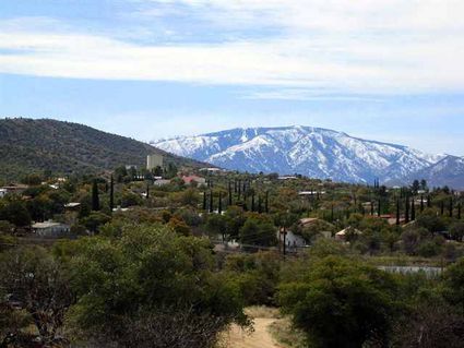
Mt. Lemmon From Oracle
After what sometimes seems an interminable summer, Arizonans welcome autumn with great enthusiasm. They join others across the country in celebrating the colors that signal the freshness of fall. The vibrant aspens, maples and oaks of Arizona’s outdoors comprise a wonderful palette of color.
Many have offered their opinions about the ideal times and places to view the kaleidoscope of colors, and here are some of the favorites — road trips that take you through the grandeur of a Southwestern fall from now through, in many cases, December.
There may be other “leaf-peepers” in these areas, but if you can get away during the week, you might find the viewing less crowded. Here are some of our favorites.
Prescott Area
If you start your tour of colors here, you won’t be disappointed; instead, you will be mesmerized by the beauty of an Arizona fall.
From Whiskey Row, drive south on Montezuma to the turnoffs for Ponderosa and Crown King. Turning east onto Indian Creek Road, you will see the gorgeous blend of gold canyon grape vines with crimson Virginia creeper.
Now, drive on through Ponderosa Park, through Wolf Creek campgrounds and then turn south on Senator Highway. Be ready for a blaze of red as the big-tooth maples almost jump out from the canyon walls. Gorgeous!
As you come to Walker Road, be entranced by more maples, then turn around and go back to Prescott. At State Route 69, go west about three miles to State Route 89, and then turn north.
Now, look for state Route 89A, which will take you to the old mining town of Jerome via Mingus Mountain. The eight miles you’ll travel are filled with gold and red, a view of absolute splendor before you drop into Jerome.
Next you could wander through Cottonwood, veering left onto State Route 260 that leads to Sedona.
“But, wait, there’s more!” We recommend a detour on Page Springs Road, which wanders with Oak Creek past vineyards and golden banks. You might also stop for a refreshing break at one of the wineries or at the Page Springs Fish Hatchery.
Turning back then, retrace your steps to Route 89A and turn east toward the incredibly beautiful areas of Sedona and Oak Creek Canyon.
By the way, as you reach Slide Rock State Park, it would be a shame not to sample the fresh cider made from historic apple trees.
Sedona And Oak Creek Canyon
Although this area offers incredible scenery throughout the year, even the beauty of a New England fall could find Sedona and Oak Creek Canyon competitors on a scale of autumn beauty. Not only are the fall colors gorgeous in themselves, but also they are intensified by the backdrop of scarlet rock.
Highway 89A is the route to take north from Sedona, following the creek line. Layers of color from the, alder, big-tooth maples, cottonwood, sumac, sycamore, velvet ash, Virginia creeper, willow and others tantalize visitors and remind us of a many-layered, colorful torte.
This is only a sketch of the masterpiece; for more details, visit http://www.redrockcountry.org.
From the canyon floor, continue through numerous steep switchbacks on up to another favorite beauty: Flagstaff.
Flagstaff
Want to lose yourself for a moment in deep conifer forests filled with colorful golden aspens? From the main part of Flagstaff, drive about 12 miles northwest to Hart Prairie Road (Forest Road 151) along the west side of the San Francisco Peaks. Although a bit bumpy, FR151 is manageable in a passenger car.
To check on guided nature walks through the Nature Conservancy’s Hart Prairie Preserve: http://www.nature.org or call (928) 774-8892.
Another aesthetically pleasing idea is to hike the Abineau-Bear Jaw Loop through the wooded canyons on the north side of the San Francisco Peaks. To access, near the end of FR151, turn right on FR418 and drive about 3 miles to the Abineau Trailhead turnoff. To check accessibility first, visit http://www.fs.fed.us/r3/coconino or call (928) 526-0866.
The White Mountains
Driving from Alpine to Springerville is a remarkable experience, especially during the fall in Arizona. For instance, taking Arizona 180/191 north from Alpine for about six miles and turning east onto Forest Road 56 will open your eyes to awesome beauty.
Terry Flat is a gorgeous destination: it’s a meadow nestled up to Escudilla Mountain and swathed in golden aspen against green conifers. You are right at the door of Escudilla Mountain National Recreation Trail, a great hike.
After wandering zigzag up Profanity Ridge, hikers view open meadows with all the yellow and orange and gold hues of a perfect autumn painting. Alternating between forest and meadows, the trail ends at a fire tower after three miles. From Terry Flat, take the left fork past Toolbox Draw and go a half-mile to the trailhead. More information is available: (928) 339-5000, http://www.fs.fed.us/r3/asnf.
Another favorite drive is south on Arizona 191 to Hannagan Meadow where not only colors abound but also elk and other wildlife. Check out http://www.hannaganmeadow.com.
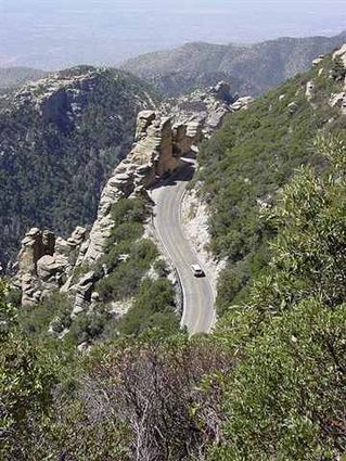
Mt. Lemmon
Although this is in a totally different direction and is no doubt a trip of its own, one of our favorite destinations in any season, but especially in the fall, is Mt. Lemmon above Tucson.
The highest peak in the Santa Catalina Mountains at 9,157 feet, Mt. Lemmon is in the Coronado National Forest. It was named in honor of botanist Sarah Plummer Lemmon who trekked to the top of the mountain with Native American guides by mule and foot in 1881.
Driving up the Catalina Highway brings you to the small town of Summerhaven, which has now rebuilt most of the small cabins lost in the Aspen Fire of July 2003.
Mt Lemmon Observatory is at the peak and its telescopes are used for astronomical research today by many educational institutions, including the University of Arizona. It is a unique research and teaching destination.
The Catalina Highway climbs up the mountain from the east side of Tucson to Summerhaven. The beautiful, curving road is a favorite drive for tourists, for locals escaping summer's heat and for cyclists; it has been designated as the Sky Island Parkway, part of the US National Scenic Byway system.
Mt. Lemmon
The backside of the mountain is visible from Oracle, Ariz., and from there one can travel to the summit on state highway 77, northeast of Tucson. It offers a secondary route to the top.
This route is popular with off-road 4x4 drivers and with off-road or dual-purpose motorcyclists. This road ends at the Catalina Highway near Loma Linda. Before the Catalina Highway was built, it was the only route up the mountain.
These are only some of Arizona’s incredible scenic destinations, and there is no better time than fall to explore the colors and beautiful leaf displays of the state.
Another resource: AAA’s Highroads magazine often features these and other trips that explore the panorama of the Grand Canyon State. What better year to do so than during Arizona’s centennial?


Reader Comments(0)