

Superstition Mountain Solitude
January 15, 2015
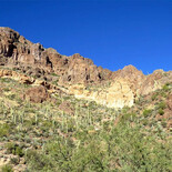
SHEEP SPOT -- This is where the sheep were. This is about 3-1/2 miles up 172.
One of our favorite things to do is take day drives in Arizona. Recently we decided to head east for a change, since every road we take off the highway going north seems to be closed to shooting. We wanted to do a little target practice, so we headed down Highway 60 toward Superior.
At first we tried Mineral Mountain Road which goes south off 60 just a few miles past Florence Junction, but that road also had "No Shooting" signs. This time, for State Trust Land. According to my map, it changes to BLM land a ways down the road, but there were dozens of ATV trailers parked everywhere, and it seemed a bit busy for our taste.
Exploring Begins
We got back on Highway 60 and headed back toward Florence Junction, and we took the Queen Valley turnoff. We really had no idea where we were headed; we were just looking for a place to shoot. The map told me that the Tonto National Forest wasn't too far away, so after a couple of miles on the Queen Creek road, we took Hewitt Station Road (357) to the right. Approximately four miles later, we took FR 172 north.
A Side Note About Behavior
At first, there seemed to be a lot of people around, most of them recreational shooters. I'm sad to say that there were a lot of places where shooters had left their trash and targets - also lots of bullet holes in signs. That's the type of behavior that causes areas to be closed to shooting, and I hate to see that. There are lots of quads in this area, too – and this was on a weekday! But, we kept on going, and the farther we went, the fewer people we saw.
Around three miles up FR 172, we took a right turn onto FR 252 and drove around a bit. We finally did find a place to shoot, and it was lovely. By the way, we not only policed our brass; we also picked up trash that was there when we got there.
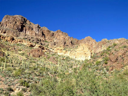
Gorgeous Scenery
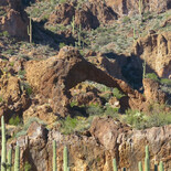
The day was still young, so we decided to see what was down FR 172. What a treat! The scenery was gorgeous – I've rarely seen such thick stands of saguaros, and the rock formations are incredible. This is the southeast part of the Superstitions and the country is indescribably beautiful. There are cliffs, canyons, hoodoos, holes through the rocks, and an arch that looks like an elephant!
An Elephant? Really?
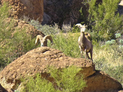
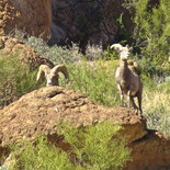
We didn't even know about Elephant Arch. We had stopped on the side of the road in a canyon area because John spotted some bighorn sheep on the rocks. I have no idea how he saw them – they were 250 yards away! But we got out so we could see them and shoot some photos.
While we were stopped, the rancher came by from the north and he paused to talk to us. He had his range-finding binoculars and we were all chatting and looking at the sheep. The sheep, by the way, never moved. They just stood there and stared at us. No doubt they felt quite safe being that far away.
While we talked to the rancher, a truck came up from behind us and a young man and his girlfriend got out to see what we were looking at. We helped them find the sheep and then the boy mentioned that he and his girl were out to take a look at Elephant Arch. What??? The rancher said yes, it looks like the head of a mammoth and it's right up the road on the left side.
Yes, You'll See It
You'll get almost to the top of a little rise, and if you look to the left, you'll see it. There's a pull-out with just about room enough for one car to park. Well, that was a treat. We let the young people go ahead of us, and sure enough – we saw an arch not too far from the road, and it did indeed look like an elephant's head. As close as I can figure, the Elephant Arch is just under four miles from the junction of 357 and 172.
We dawdled quite a bit, stopping to take photos, give the dog some water, and look around. I hadn't planned on any hiking so I didn't bring my GPS. Mental note to self: Bring GPS even when not hiking. My phone didn't pick up any signals back in the mountains, so I can't be more precise about distances. Sorry.
More Wandering
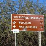
If you take 172 for 8 miles, you will come to a split where it divides into 172 A and 172 B. The left fork, 172 B, goes to the Woodbury trailhead. If you take 172A to the right, you will come to The Roger's Trough Trailhead, from which you can access the Rogers Canyon Trail.
This is definitely a hike I will come back for. Getting to it takes at least an hour in a 4WD vehicle, so odds are you won't run into anyone else on the trail.
At the trailhead, follow Reavis Valley Trail 109 for about a mile and a half until you come to the junction with trail 110, Rogers Canyon Trail.
Take the left fork. This trail mainly follows Rogers Creek, and if you keep your eyes open, you will see some very-well-preserved cliff dwellings on your right. They are protected, so please do not climb on them or take or destroy anything. To get to the ruins is an 8-mile round trip, mostly downhill on the way out, but uphill on the way back.
Many Trails
There are a lot of trails that intersect the trail accessed by the two trailheads. There is an excellent map online here: http://www.superstition-sar.org/downloads/iron_mountain.pdf. This is from Superstition Search and Rescue.
The Tonto National Forest Maps from the Forest Service also show some of these trails, but in a much smaller scale. You can also buy a detailed quadrant map at a good map store. The USGS topo map quadrant name is Iron Mountain.
Need To Know Where You Are; Inform Others Too
On this kind of hike you absolutely need to know where you are and where you are going at all times. Even these days, plenty of people die in the Superstitions, so be careful. Take a lot of water, and don't do these hikes in the summer. Even in early January, the temperature was 84 degrees the day we were there.
Roads 357 and 172 are dirt roads, and 172 in particular often gets washed out. A 4WD vehicle is needed. We saw a lot more quads on the road than trucks and Jeeps. Our 4WD Rav4 had no trouble at all, but there are some steep rocky areas on the road, plus it crosses Queen Creek a number of times, and if there has been rain, the creek may be running, or it may have run strong and washed the road out.
Cell service is spotty, so be prepared and make sure you let someone know where you are going and when you can be expected back. The Superstitions are always an adventure: their beauty, the legends, the wildlife and the strange rock formations – they'll keep you coming back time after time, even if you don't believe in the Dutchman's Mine!
Information From The Tonto National Forest
To get to the trailheads: A 4WD vehicle is needed, and horse trailers are not recommended. Drive east on Highway 60 from Florence Junction to the Queen Valley Road (approx 2 miles). Follow this road (paved) to Hewitt Station Road 357 branches to the right.
About 3 miles down this road you will see the turn off for 172 to the left. Keep going for a little over 9 miles (bear left at the junction of 172 A and B. There will be a road off to the right, and a very short distance down this road is the Woodbury trailhead.
From here you can get to JF Trail 106 and Woodbury Trail 114. The east part of Woodbury trail is an old mining road, and the west part gives you access to Fraser Canyon and the Coffee Flat Trail 108.
For the Rogers Trough TH, bear right and follow 172A (about 8 miles up 172). From Rogers Trough TH you can get to Reavis Valley Trail 109, West Pinto Trail 212, and Roger's Canyon Trail 110 – the one with the ruins.
Since this trail follows the creek, there are trees and the trail is shaded some of the time, depending on when you are there.


Reader Comments(0)