

By AZBW
A Salute To Swimming
Hop In; The Water's Fine
July 15, 2014
Slide Rock
It may be a desert state, but Arizona has many great swimming holes.
Nestled here and there near mountain springs and along tributaries of rivers, these natural spas are popular with hikers, picnickers and just about anyone who enjoys time in and around the water.
Some of the following entail a drive; others require a short walk or a bit of a scramble. A few can only be reached after a long, hard hike.
Keep in mind, though, that you are not the only one who wants to cool off in the water; there may be crowds at any of these spots - especially on a summer weekend. Be ready for "company."
Water Wheel
The Mogollon Rim country north of Payson - laced with many creeks and canyons - is excellent for swimming holes. Some of the most popular ones are just east of the Water Wheel Campground, a recreation area off Forest Road 199.
As you hike east along the creek, you'll discover a series of swimming holes. The first few are wide and shallow; the ones farther east are narrower and fairly deep. The farther upstream you go, the fewer people you'll find.
About a quarter-mile from the road is a series of small waterfalls and pools at the base of a narrow granite gorge, polished smooth by water and time.
From Phoenix, take Arizona 87 (the Beeline Highway) north to Payson. About 2 miles north of Arizona 260, turn east (right) onto Houston Mesa Road and continue 7.6 miles to a large camping/picnic site on the right. Park here and walk up the creek.
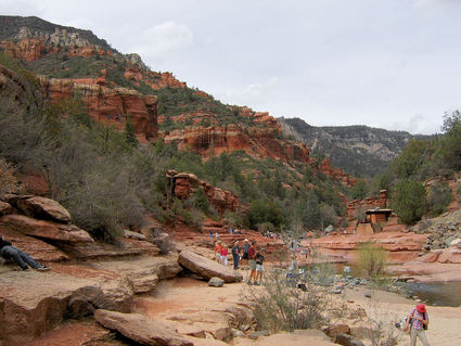
Slide Rock State Park
A hot summer day is perfect to enjoy the natural waterslides of Oak Creek. Kids and adults can enjoy the luxury of cool swimming holes and smooth rock chutes amid the exquisite scenery along Oak Creek Canyon.
Access is easy (check, though, for any restrictions following the Slide Fire) and there are restrooms, picnic tables and a small concession and gift shop, Slide Rock State Park is popular, especially on summer weekends.
When you are ready to "dry out," try a stroll along one of the short, scenic hiking trails. Bird watchers will delight in this rich riparian area.
A word to the wise, though: No pets or glass containers are permitted in the swimming areas.
From Phoenix, take Interstate 17 north to Exit 298 (the Sedona exit), then follow Arizona 179 west and north about 15 miles into Sedona. Now take Arizona 89A north about 7 miles to the park.
Bell Crossing
There's some history here. Rancher Charles Bell built a cattle trail in this spot in the 1930s, but now it's a favorite among hikers.
After a long, hot 3.5-mile hike across a slightly scenic landscape, the crossing -where the Bell Trail crosses Wet Beaver Creek - appears as an oasis, shaded by cottonwoods, sycamores, willows and ash.
To reach the swimming hole, also known as "the Crack," head upstream from the crossing to a series of wide and sometimes fairly deep pools along the creek - perfect spots for a quick, cooling dip.
Although it can be a bit of a challenge in places to get beyond the Crack, the farther you go, the fewer the people.
From Phoenix, take I-17 north to Exit 298 (the Sedona exit). Turn east and follow Forest Road 618 about 2 miles southeast, then turn left onto FR 618A and proceed to the parking area.
Hell's Gate
Just the opposite of its name, Hell's Gate Wilderness is a lovely place, with ragged rock walls towering hundreds of feet and a lush riparian corridor providing a green carpet through the desert.
There's no doubt that it's a long, hot, steep and heavy hike down to Hell's Gate, but it only makes arriving at the creek that much more rewarding. (And it cuts way down on the crowds.)
Not quite a clear path until you reach the creek, but a trail continues on the other side, winding west a couple of hundred yards to where Haigler Creek joins Tonto Creek. The banks are full of brush, but there are some good camping spots near the confluence, and the verdant areas along the creeks are inviting places.
From Phoenix, take Arizona 87 (the Beeline Highway) north to Payson. Turn east on Arizona 260 and go about 11 miles. At mile marker 263, turn south onto the unsigned Forest Road 405A and drive half a mile to the trailhead.
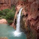
Havasu Falls

Havasu Falls
The waters of Havasu Falls in the western Grand Canyon are an amazingly exquisite turquoise. Although a trip here requires a lot of planning, some money, and a long hike, the wonder of soaking in some of the most beautiful water ever is worth every plan, every dollar, and every effort.
Whether you stay at the lodge in Supai Village or the campground beyond, you can explore Havasu, Mooney and Navajo falls. And, if you want even more water, you can hike all the way down to the Colorado River.
From Hualapai Hilltop, roughly 60 miles north of Seligman, it's a moderately difficult 8-mile hike to Supai Village and another 2 miles to the campground.
From Phoenix, take I-17 north to Flagstaff. Turn west on I-40 and go about 75 miles to Seligman. Take Route 66 about 28 miles northwest to Indian Route 18. Turn right and go about 60 miles to the parking area at Hualapai Hilltop. There are no facilities at the trailhead, but you may camp there. No permits or fees required.


Reader Comments(0)